The legendary mountain kingdom of Hunza lies on the ancient trade route to Sin Kiang. Hunza is an earthly paradise whose inhabitants are renowned for their longevity, their simplicity and natural diet. Karimabad is the main town of Hunza which is like a huge hanging garden containing mud and stone houses, orchards, terraced fields, shops, work- shops, schools, restaurants and hotels etc. The river Hunza and the road cut this natural bowl of snow crested high hills. The houses and fields are stretched right from the road level up to the snowline level. This valley is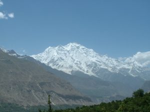 composed of terraced ridges running from the high pastures down to the river, with extensive irrigation channels bringing melt water from the glaciers to the terraced fields and villages. A wide variety of crops are grown here; including potatoes, barley, wheat, and vegetables – along with apricots, apples, cherries, almonds, and other fruit/nut crops. We hiked the valley during the apricot tree bloom, a beautiful time of spring of planting and blossoms.
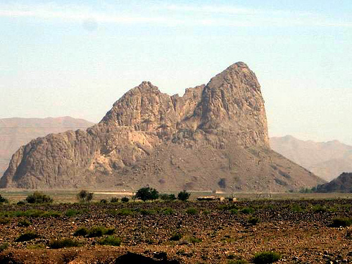
Snow covered high mountains and great glaciers abound Hunza & Nagar valleys, The most magnificent being 7,788 metres high Rakaposhi (above). Hunza is also known for its unpolluted mountain air, which caused this area to be known as “Shangri-La”. The blossoming and autumn at Hunza are worth seeing and attract thousands of tourists, especially from Japan. Orchards of mulberry, walnut, apricot and apples abound. In the autumn, when the sun converts the valley to burnished gold with its back drop of snow covered white peaks, the setting is particularly idyllic. Gulmit is about 35 km north of Karimabad. Further on the way up, the road becomes more rugged as it passes through narrow gorges, but suddenly it opens up into a broad valley. Gulmit is best known the unique Passu Cones (below left). This huge mountain dominates the area from Gulmit to Hussaini and offers unforgettable and spectacular scenes. Further ahead is the Borit Lake. The lake receives glacial water and migratory birds during summer. It is about 1.5 kilometer off the road.
History of Hunza: Hunza has been ruled by a family known as Mirs of Hunza for 960 years. Hunzakuts are believed to be the descendents of five wandering soldiers of Alexander the Great. The people of Hunza speak Brushuski, an aboriginal language. This princely state retained its isolated independence for a long time in the remote part of the areas which now from the Northern Areas of Pakistan adjoining the Sinkiang Autonomous Region of China. During early nineteenth century, Hunza resented Kashmir’s attempts to gain control and its rulers periodically expelled Kashmir garrisons, threatened Gilgit, and politicked with the rulers of Kashgar to the north where the Russians were gaining influence. Fearing Russians infiltration into their northern frontiers, the British took over direct political control at Gilgit in 1889. Incessant fratricidal intrigues in Hunza and Nagar made the areas doubly insecure. This, coupled with the Mir of Hunza’s consistent intransigence induced the British to march on Hunza in December 1891, where they fought a decisive battle at Nilit, 60 km beyond Diaynor Bridge. After this the British garrisoned Aliabad until 1897 when Hunza became a princely state protected by the Government of British India. After the Pakistan was created in 1947, the people of Hunza also gained liberation and the princely state was merged in Pakistan.
Baltit Fort at Karimabad was built around 450 years ago and was the residence of the Mir of Hunza. The fort was built in Tibetan style for a princess of Baltistan who married the Mir. Right: Tibetan “sky-light” in the roof of the fort. One can see the Rakaposhi and Diran peaks from the roof of Baltit Fort.
Nagar Valley: The Nagar valley is situated at an elevation of 2,438m (7,999 feet). Nagar Khas is the main town and the capital of the former Nagar state. The Spantik peak (Golden peak) can easily be seen from here. Gulmet is the popular tourist attraction in Nagar because of the spectacular scenery of the surrounding mountains like Rakaposhi at 7,788m (25,561), and Diran.
Nagar and Hunza were once collectively called buroshall and their capital was capal dosuk. Nagar was an independent principality for 1200 years, which existed until 1974. The British gained control of Nagar and the neighbouring valley of Hunza between 1889 and 1892. The Tham (Chief) of that time Azur Khan sent in exile to Kashmir. The British retained Nagar’s status as a principality until 1947. The people of Nagar were ruled by a local Mir for more than 1200 years, which came to an end in 1974. Although never ruled directly by neighbouring Kashmir or the British, Nagar was a vassal of Kashmir from the time of Maharaja Ranbir Singh of Jammu and Kashmir. The Mirs of Nagar sent an annual tribute to the Kashmir Durbar until 1947, and along with the ruler of Hunza, was considered to be among the most loyal vassals of the Maharaja of Kashmir. The state bordered the Gilgit Agency to the south, the former princely state of Hunza to the east, China to the north and Afghanistan to the northwest. The state capital was the town of Nagar Khas (also known as uyum Nagar) The area of Nagar now forms the Nagar 1 upper Nagar and Nagar 2 lower. Nagar and forms two tehsils of the Gilgit District.
The Hunza Sacred Rock (above left) is a rock formation covered with petroglyphs, including the ibex motif used on this site for Northern Areas Pages. This rock is located close to the river, behind which can be seen Altit fort many thousand feet up. A spectacular view Lady Finger mountain top (above right) can also be witnessed from Hunza. Lady Finger mountain (above right -6,800 metres) and ulter peak (above centre) remain still unclimbed. Many people lost there lives in attempt to climb it.
Like all other valleys of Pakistan, the best time to be in Hunza and Nagar is from mid April to the end of September. The maximum temperature in summer during the day is 13C. The weather becomes very cold during the winter, mainly from the October to end of March. The minimum temperature can be -14C.